When analysing large samples like geological materials, it can sometimes be difficult to get a quick understanding of the sample; for instance, in determining, what the primary mineral phases are and in what proportions they exist, along with which minor phases are present and what the texture of the sample is.
A perfect solution for this challenge is to use AZtecLive’s Large Area Mapping functionality to automatically map a large proportion of the sample - collecting individual electron image and x-ray spectral maps in a grid pattern. Using this functionality, we can gain a good understanding of our sample by acquiring data from multiple fields of view, each with sufficiently high resolution. The maps that are collected will contain spectra at each pixel, so the acquired data set can be further analysed after acquisition to find the composition at any point in the area.
This sounds great, but the question can still be asked as to whether the analysed area captures the whole of the area that we’re interested in – particularly when the sample is irregular in shape. This uncertainty can occur because of the high magnifications at which SEMs operate (even when their lowest magnification is used) – in navigating around the sample, we are limited by the single field of view. An alternative to this is to use an optical image of the sample that we register and use to navigate with. This not only helps us greatly in finding sites of interest and in setting up areas for large area analysis (without missing any critical parts!) but it also improves our confidence in moving around – particularly if we are working remotely.
In this blog, I will explore how we can use image registration and to select the desired area for Large Area Mapping using a real-life sample - a granite, which is a coarse-grained intrusive igneous rock that was formed during the cooling of molten magma. It is composed mostly of quartz, alkali feldspar, plagioclase, micas (biotite or muscovite) and some trace minerals. Have a look at the video below to see the process:
Figure 1: Video showing image registration and setting up area for Large Area Mapping
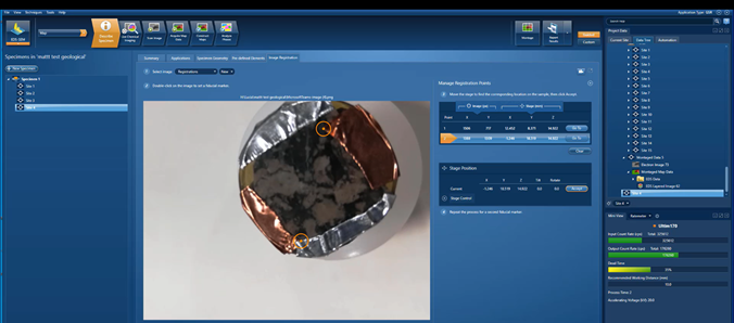
Figure 2. Optical image registration
The video shows the image registration process and then how the registered image is used to define an area that will be used for mapping. Image Registration works by taking an image (e.g. an image taken with a phone camera) and registering two stage positions for two corresponding locations on that image (by selecting points in the image and finding those same points by moving the SEM stage).
Then, when we want to move to a point of interest, that point is selected in the registered image, and AZtec sends the command to move the SEM stage to the point selected on the image. Basically, we have enabled point-and-click movement around the sample. We can even pan and zoom into the registered image, so that we can navigate to precise points of interest.
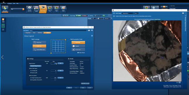
Figure 3: Defining measurement area using image registration
Having registered the image, it is then easy to navigate around the sample and to select a desired area for Large Area Mapping. The area to be analysed can be defined as a point (single field of view), circle, rectangle or quadrilateral. The user double clicks to select the point(s) defining the area on the registered image, the stage moves to that point, and the user then accepts the stage coordinates to define the analysis area. By doing this, it is easy to see on the registered optical image that the desired parts of the sample have been covered. The field coverage approach can then be chosen to define how the fields will be placed with respect to the defined acquisition area.
I hope this blog emphasised how Image registration in AZtec can help users to navigate around samples and speed up the process of setting up Large Area Maps. Having a good overview with an optical image for navigation makes setting up desired measurement locations easier and also enhances confidence in moving around. I’ll be following up on this blog with a discussion of the large area map that was acquired from this area – keep a look out for that blog later in the year!
To learn more about our AZtec Large Area Mapping click here.